Updated August 22, 2023. Whether it’s a bumpy ride on a gravel path, a leg-burning road run, a chance to practice your jumping and rock-dodging skills, or just sightseeing on an easy street cruise, there’s a route for everyone in this region. Get on your bikes and ride!
Beginner Bike Trails
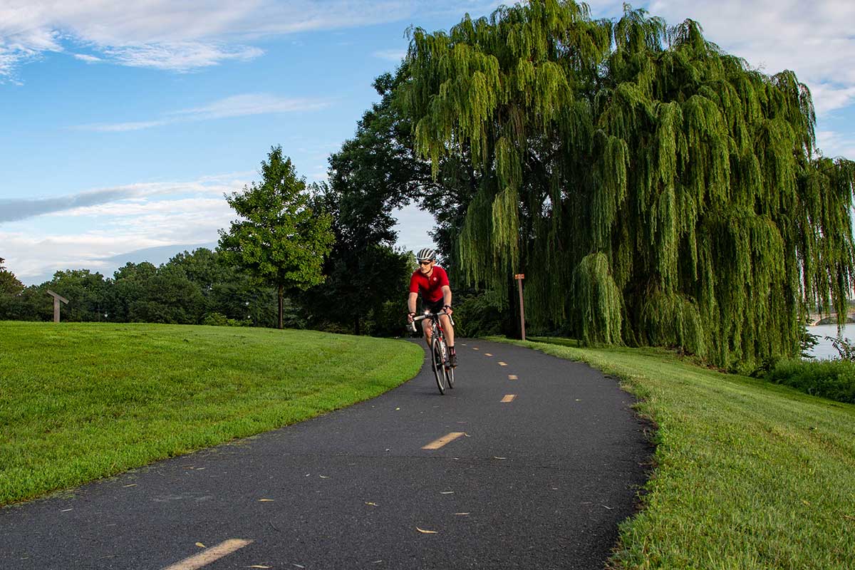
Route: Mount Vernon Trail (Rosslyn to Mount Vernon, 18 miles)
Start at the trailhead parking lot in Rosslyn adjacent to the Theodore Roosevelt Island entry. This bike route is a spellbinding trip along the Potomac with views of the Lincoln Memorial and Washington Monument (look — there goes the president’s helicopter!) as you pedal on relatively flat terrain, with just a few up and down bumps around Reagan National Airport.
Take a minute to hydrate in Old Town Alexandria after your first 8 miles — there’s a Starbucks on King Street along the route — or get a quick bite to eat at any of the restaurants. If you have the stamina, head the next 10 miles to Mount Vernon, and experience some of the amenities there.
Or, as an alternate route, you could follow the Mount Vernon trail south through Alexandria under and up to the north side of the Woodrow Wilson Bridge, where you can take a somewhat challenging 4-mile, 45-minute jaunt over to National Harbor, which has a number of great restaurants.
Tips
Keep in mind that the last mile or so on the way to Mount Vernon gets hilly. Save up a little strength — you’re going to need it. You may want to arrange for transportation back to Alexandria if you get gassed from that last mile. Otherwise, the ride back to Alexandria is pretty much downhill. Back in Alexandria, you can hop on the Metro at King Street and take that to Rosslyn to complete your round trip.
Coming off this trail near Reagan Airport is a bike exit to Crystal City, and it’s used by a lot of Pentagon employees who are generally hard-riding, all-business types of riders. If you’re riding mornings between 6 and 8 a.m. or evenings between 3 and 6 p.m., keep an eye out. They’re a bit impatient.
Time: 1.5 to 2 hours
Degree of difficulty: 5 out of 10
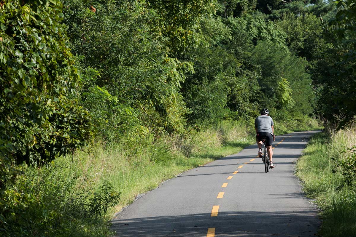
Route: Washington and Old Dominion Trail (Falls Church to Reston Town Center, 14 miles)
This is one of the most popular bike routes in Northern Virginia for a fun ride anytime.
The W&OD Trail starts in Shirlington and ends in Purcellville, a 45-mile ride. But for a beginner wanting to experience the best part of this route, jump in at Falls Church, at W&OD mile marker 6 near the intersection of Washington Street and I-66 in the north part of the city.
You will cruise easily on a mostly flat route 6 miles to Vienna, where you can hydrate by the Old Red Caboose, a historical restoration of a train station; stop off at some of the nearby restaurants or bike repair shops or just continue down the trail.
The ride from here to Reston Town Center, about another 8 miles, is a truly enjoyable, quiet, peaceful ride — with a few wide street crossings where you really have to pay attention (such as Hunter Mill Road) and lots of amenities waiting for you in Reston.
Tips
Count on a lot of bike and pedestrian traffic on this route, especially on weekends, and not everybody understands the courtesy expected on all sides. Make sure you use your bike bell or otherwise warn people in your path before you pass them.
What you probably didn’t notice on your ride out to, say, Vienna or Reston is that the trail has a very subtle elevation rise along the way. You’ll feel it in the descent riding back … and it’s a great feeling to pedal a little and cruise a lot.
There are seven breweries near or even along this route, including the Caboose Brewing Company in Vienna.
Time: 1.5 to 2 hours
Degree of difficulty: 4 out of 10
Gravel Bike Trails
Route: Haymarket to Middleburg, 35 miles
Start on the main drag in downtown Haymarket (Washington Street/John Marshall Highway), and ride about 2 miles north-by-northwest on Antioch Road before taking a right onto Waterfall Road/Hopewell Road, getting to gravel where the paved road ends at the intersection of Bull Run Mountain Road and Hopewell Road.
Go right to begin a slowly rolling countryside ride past picturesque old Virginia farmhouses and snazzy new multimillion-dollar mansions. The road shifts from gravel to paved off and on and then levels off to smaller rises.
Right past historic Rectortown is a long stretch of gravel that ends at Highway 50. You might want to hang a bit at Slater Run Vineyards a few miles before 50 … or you might just want to call that your end point for the day.
If not, it’s a mostly paved road the rest of the way to Middleburg. It’s heavily wooded along the gravel road, which makes it ideal for shady spring and summer rides and maybe a stop-off picnic break along the way.
Middleburg is a beautiful place to end the ride, with a quaint downtown full of antiques and art shops, unique dining rooms, and multiple wineries. If you want to take the full 70-mile run past Middleburg and back to Haymarket, go for it. Otherwise, it may be a good idea to have someone with a car meet you in Middleburg at the end of your ride.
Tips
The rural beauty of the road is distracting, so keep an eye on where your tires are going. The gravel here is fairly small, but there are occasional larger stones, mostly toward the edges.
Any gravel road ride is not for beginners, but rather for seasoned riders who are ready for the changing road conditions and come equipped to handle any sudden emergency. Bring a first-aid kit, food, and a battery-powered light. Be sure to check cellphone coverage before going out.
As the area develops, some of the gravel roads may become paved, or there may be other construction obstacles to a smooth ride.
Time: 3 to 4 hours
Degree of difficulty: 6 out of 10
Route: Leesburg to Brunswick, 32 miles
This mixed-surface gravel road round-trip route starts in Leesburg, goes west and south through Woodburn, and then turns north to Morrisonville, through Lovettsville, with a side jaunt to Brunswick and then a turn back south. There are just a few spots of actual gravel road on this part of the round-trip route — which is pretty common for any gravel bike run in this rural but developing part of the state — but you can chill out in Lovettsville at Market Table Bistro before pushing on across the Potomac to Brunswick, which is a great destination. You may just want to wrap up your ride here with a frosty one at the Smoketown Brewing Station.
But if you want more gravel and less paved road, go ahead and continue from Brunswick mostly due south on this route back to Leesburg, with a ride that begins with an 8-mile beauty of a tour along the Potomac. It’s mainly gravel here, with a wonderful rural setting all the way through Taylorstown, and a great flourish of a long all-gravel up and down ride for the last 7 miles. That’s a 64-mile round trip ending with a breezy descent that will set you up for a much-deserved celebration in Leesburg.
Tips
Beware of soft pavement due to heat along the paved parts of the road, and large rocks mixed in with smaller rocks and other field debris.
Always check the weather before going out on a gravel-road ride. Even a brief rain shower can turn the road into a muddy, slippery, and dangerous mess very quickly.
Time: 1.5 hours
Degree of difficulty: 7 out of 10
Mountain Bike Trails
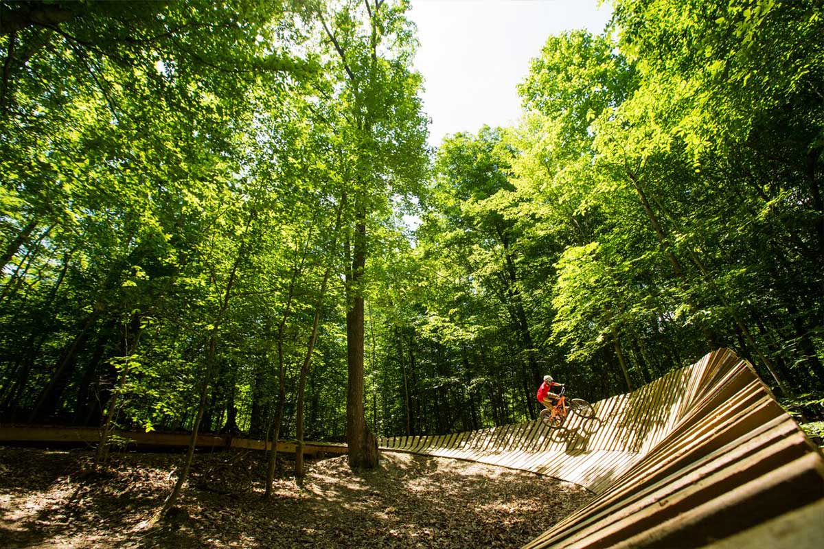
Route: Meadowood Tour, 7 miles
The Meadowood Tour is a quick, family-friendly mountain-trail bike ride around the trails of the Bureau of Land Management’s Meadowood Special Recreation Management Area, accessible from Lorton via Gunston Road, an exit off Richmond Highway, where there is a parking lot and trailhead.
You can ride the main loop and the three internal trails, including Boss, Stinger, and Yard Sale trails. This is a relatively new bike trail and the only BLM trail on the East Coast, and it offers riders of all levels many challenges.
This route will take you through several trails in mature hardwood forests in the Mason Neck peninsula. It begins with a series of quick lefts and rights for about a mile. But if you take a left just before the first mile marker, you’ll go over the Big Berm, which is the beginning of the Boss Trail downhill.
The Big Berm features an elevated boardwalk. There is another elevated deck alongside a section of wetlands about 3 miles in — you can hang out there and take in the view before heading out again.
The Boss Trail is the first of the three internal loop attractions you’ll find as you ride along the perimeter loop. It includes several human-made features: an elevated boardwalk, two big wood berms, and several jumps and rock gardens.
All of the features are easily rideable and contain alternate lines for less experienced riders. You come face-to-face with The Stinger about 4 miles in, which features a fast downhill route with tight turns for about a mile. Then, at the 6-mile mark, Yard Sale features a jump line where riders can show off their coolest mountain-rider moves.
Tip
There is a huge indoor ski jump and winter sports facility, Alpine X, being built near this mountain bike facility as part of the new $225 million Fairfax Peak project, which will have a large hotel and other amenities. It’ll be a great place for the whole family to play either before or after their Meadowood tour. Until then, you can visit nearby Occoquan, a nice little historic town just 3 miles away from Lorton with antiques shops, art galleries, bistros, wine bars, boutiques, and even a scuba shop.
Time: Depends if you want to stop off for views or do jumps, but about 1.5 hours
Degree of difficulty: 3 out of 10
Route: Lake Fairfax Tour, 7.6 miles
This mountain-riding trail is accessible off the W&OD bike trail just east of Reston, or about 1 mile south after the turn onto Lake Fairfax Drive, and is part of a recreational complex in this part of Reston. The trail swings around and through the Lake Fairfax campground and park and, of course, up to Lake Fairfax itself, where you can stop and enjoy a quick dip.
Various riders have reported that the trail is a bit dated but still active, so keep an open mind and a close eye on where you are going. The route is home to several big bike races a year, including European-style cyclocross races in the fall and winter, which tend to rough things up. It’s designed with a series of rises that never get too steep but are challenging nonetheless, given the conditions of this unpaved trail. Around the 7-mile mark, it climbs steadily to its highest point all the way back to the trailhead, so remember to pace yourself.
Tips
Make sure there’s no big cycling event planned when you want to go.
You may want to just stay at the lake after your ride. Make plans to meet there. Bring the kids!
Time: Around 2 hours, depending on your climbing skills
Degree of difficulty: 7 out of 10
Road Bike Trails
Route: Ballston to the Capitol Building, 17 miles
Start on Fairfax Drive just by the Ballston Metro, and head east toward Rosslyn. There’s a lot of traffic in this area and a lot of pedestrians crossing against lights along the length of Clarendon shopping area, so keep a steady watch. Go left on North Lynn Street in Rosslyn, and duck right onto the W&OD Trail at an entry point you’ll see just before the Key Bridge. Take the W&OD bike trail along the Potomac for about five minutes, and then swing right up and around on the trail to the sidewalk of the Memorial Bridge.
Across the bridge is the Lincoln Memorial, always a good place to rest for a minute and people-watch. Head down to the World War II Memorial along the beautiful reflecting pool, and then take 17th Street north and cut across in front of the north side of the White House. Go right down 15th Street to Pennsylvania Avenue, and then take a left. This is the best part of the trip — a cruise up the center of Pennsylvania Avenue all the way to the Capitol — about 2 miles. It’s a beautiful site and a great place to chill and ponder what’s happening in Congress right in front of you.
Tips
Never drive on the Memorial Bridge roadway — stay on the sidewalk, and be courteous to the usual group of pedestrian tourists there.
Be careful to hug to the right side of the road and navigate around the food and merchandise trucks on 17th Street. A sudden group of pedestrians could pop up in the street here.
Time: 1.5 hours
Degree of difficulty: 4 out of 10
Route: Prince William Scenic Loop, 14 miles
This easy cruise on paved road (there are also options for a gravel-road experience) is a nice and shady run through the 18,000-acre Prince William Forest Park, one of the few remaining piedmont forest ecosystems in the National Park Service. Park at the Pine Grove Picnic Area just inside the park entrance, which is accessible from Joplin Road after exiting I-95.
The scenic loop is very easy to follow; it is shaped like a lollipop. The ride starts off easy enough. You can turn right to enter the scenic loop and, around 2 miles in, decide if you want to go clockwise or counterclockwise.
If you go counterclockwise, there’s a great downhill run. The trail continues with a few rises and falls and then descends to an elevation of 85 feet before a steady rise to 380 feet about 6 miles in. That elevation stays in place for another 4 miles before a quick and steady descent, followed by a roller coaster of ups and downs until the trail terminates.
Tip
There is a fee to use the park trail that can be purchased at the Visitor Center. It is currently $10 per person and good for 7 days.
Time: 1 hour
Degree of difficulty: 5 out of 10
Feature image of Mount Vernon Trail courtesy National Park Service
This story originally appeared in the April issue of Northern Virginia magazine. Subscribe for more stories like this.